Editor’s Note: This piece is the fourth in our series on issues raised or missing from the Draft Alternatives Analysis. That AA preferred a Sears Island development plan that would destroy at least 30 acres of important freshwater wetlands and trigger review of the illegal filling of Sears Island wetlands from the failed cargo port attempt in the 1980’s, as required by a court-ordered consent decree.
By definition, wetlands are areas where water covers the soil, or is present either at or near the surface of the soil all year or for varying periods of time during the year.1 In Maine, wetlands take a variety of forms, including marshes, wooded swamps, bogs, sedge meadows, peatlands, and vernal pools. The benefits afforded to the overall ecosystem from wetlands are numerous, from providing critical habitat for fish, waterfowl and other wildlife, to assisting in groundwater recharge, and filtering run-off which ensures the water is clean and clear water as it makes its way to the coast. Wetlands also provide immense benefits to human communities – particularly in the face of climate change – by mitigating the destructive power of floods, storms, and erosion, and acting as carbon sinks.
Prior to the arrival of European colonizers, there were an estimated 221 million acres of wetlands within the continental United States.2 According to a 2019 report by the U.S. Fish and Wildlife Service, that number has been cut in half, with remaining wetlands totaling approximately 116 million acres. Historically, wetlands were perceived as swamp land that bred insect borne-illnesses that also made travel and agricultural cultivation difficult; people were best served by avoiding, modifying, or destroying these systems. This thinking – that wetlands were places to be ditched and drained, or paved over – persisted for centuries and was perpetuated by federal policy and agencies. It was not until the late 20th century that our understanding and regulations began to change and recognize the importance of wetlands. Despite this shift, we have not yet fully moved beyond sacrificing wetlands in the name of development and economic growth. Roughly 670,000 acres of wetlands – greater than the land area of Rhode Island – were lost between 2009 and 2019 from the continental U.S.3
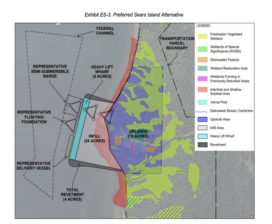
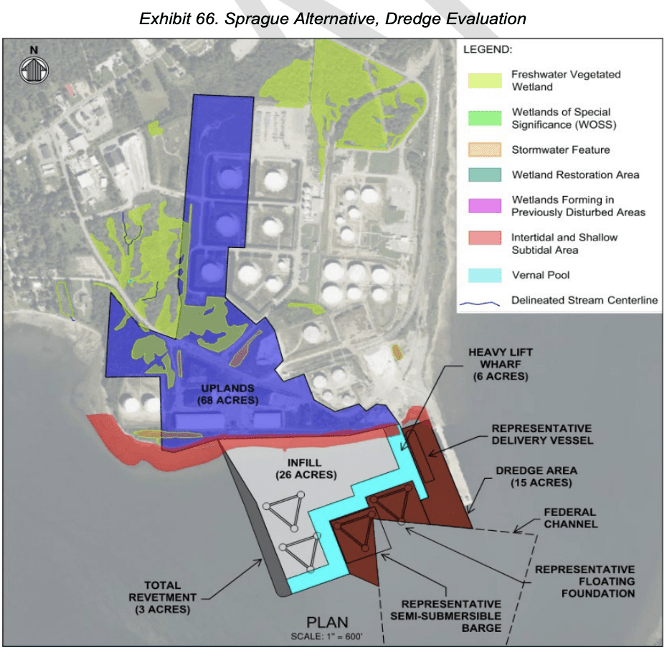
In the Penobscot Bay watershed, wetlands remain threatened. The impacts from Maine DOT’s proposed windport on Sears Island’s wetlands would be significant, and far greater than either Mack Point alternative presented in the Draft Alternatives Analysis. Construction of the port on Sears Island would destroy ~30 acres of freshwater wetlands, 24 of which have special designation as Wetlands of Special Significance. Alternatively, impacts to wetlands at Mack Point with Sprague Energy’s proposal are estimated by MDOT to be seven acres, less than one acre of which is designated as wetlands of special significance.4
The wetlands on Sears Island provide habitat not only to the wildlife that live on the island, but also migratory birds. These wetlands clean and filter water that ultimately runs off into Penobscot Bay, carrying nutrients for marine life. These coastal wetlands sequester carbon, providing significant climate benefits. Further, the wetlands on Sears Island are also integrated within a larger landscape of undeveloped forest, shrubland, meadowlands, and coastal dunes. The health of these wetlands is intertwined with the overall health of the island, and Penobscot Bay. MDOT grossly underestimates and fails to understand the impacts to coastal wetlands from the proposed project on Sears Island.
It comes as no surprise that 30 acres of wetlands and the diverse life and ecosystem they support are being brushed aside by MDOT; the agency has a checkered history at best of disregarding environmental regulations on the island, including the illegal filling of more than 10 acres of wetlands in the late 1980s. This action by MDOT resulted in a 1996 federal consent decree between EPA and MDOT that “permanently enjoined” MDOT from destroying freshwater wetlands on Sears Island. The State of Maine paid $10,000 in civil penalties plus another $700,000 in environmental mitigation as a result of MDOT’s illegal wetland filling.
In a report submitted to Congress and published by US Fish and Wildlife, Status and Trends of Wetlands in the Conterminous United States 2009 to 2019, former Secretary of the Interior, Deb Haaland, wrote:
“…Wetland loss leads to the reduced health, safety, and prosperity of all Americans. When wetlands are lost, society loses services such as clean water; slowing of coastal erosion; protection against flooding, drought, and fire; and resilience to climate change and sea level rise. Wetland losses also cause declines in fish, wildlife, and plant populations that many in our communities depend upon to make a living, feed their families, and enjoy the outdoors.”
Wetland ecosystems are in dire need of protection, and they in turn protect us. We cannot justify the destruction of wetland habitat in the name of green energy to address climate change; only by truly valuing wetlands and conserving them will we be able to address the climate crisis, and protect ourselves and the places we care about.
Jill Howell
- https://www.epa.gov/wetlands/what-wetland ↩︎
- Dahl, T.E., 1990, Wetlands–Losses in the United States, 1780’s to 1980’s: Washington, D.C., U.S. Fish and Wildlife Service Report to Congress. https://www.fws.gov/sites/default/files/documents/Wetlands-Losses-in-the-United-States-1780s-to-1980s.pdf ↩︎
- Lang, M.W., Ingebritsen, J.C., Griffin, R.K. 2024. Status and Trends of Wetlands in the Conterminous United States 2009 to 2019. U.S. Department of the Interior; Fish and Wildlife Service, Washington, D.C. ↩︎
- <a href="https://www.fws.gov/sites/default/files/documents/2024-03/wetlands-status-and-trends-2009-2019-signed.pdf%5B1%5D Note that the Maine DOT’s proposed layout for construction at Mack Point, which did not include Sprague Energy’s insight or input, identified 10 acres of wetlands to be impacted, also with https://www.fws.gov/sites/default/files/documents/2024-03/wetlands-status-and-trends-2009-2019-signed.pdf%5B1%5D Note that the Maine DOT’s proposed layout for construction at Mack Point, which did not include Sprague Energy’s insight or input, identified 10 acres of wetlands to be impacted, also with <1 acre of which was designated as a wetland of special significance. A new Mack Point plan even would avoid most of the seven acres. ↩︎