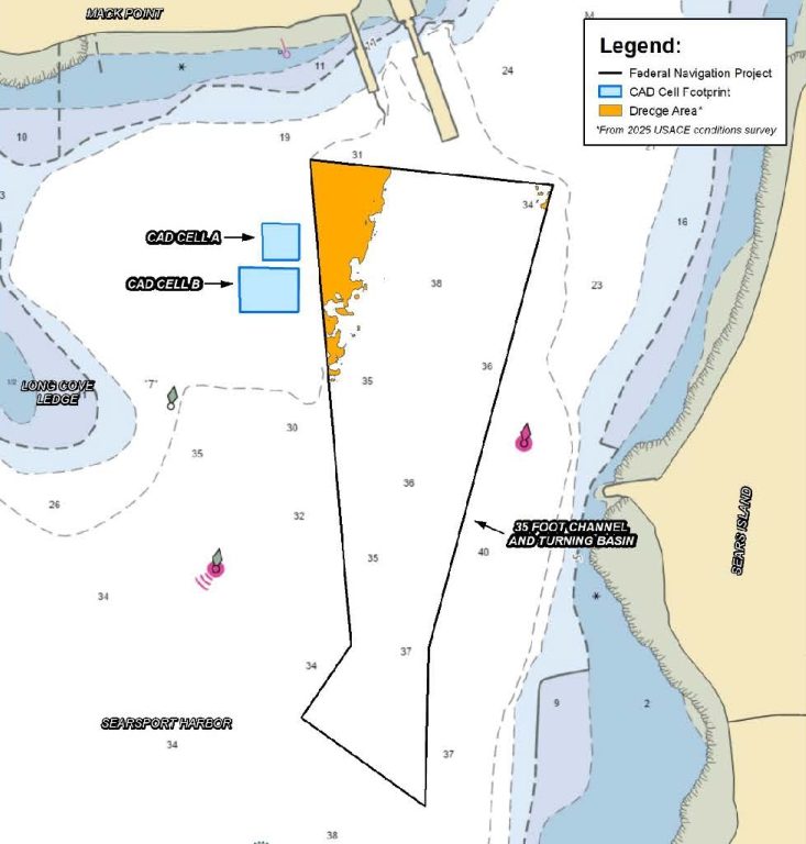
The US Army Corp of Engineers is planning to dredge portions of the Searsport Federal Navigation Channel in Upper Penobscot Bay. The channel has not been dredged since its construction in the 1960s, and the current depths cannot accommodate all ships coming in and out of Mack Point during the full tidal cycle. Dredging, while necessary to maintain navigational channels, can cause environmental harm when not done with proper environmental protections, and/or if there is not proper disposal of dredged material. There is currently an open comment period with the Maine Department of Marine Resources for the planned dredge activities in Searsport Harbor. The Alliance will be submitting comments and encourages the public to submit as well to ensure that Searsport Harbor and Penobscot Bay are adequately protected during dredging activities.
Dredging, the word really sounds ominous.
The public is being asked to comment on the planned maintenance dredge of the northwest section of the Searsport shipping channel Federal Navigation Project (FNP) that leads to the commercial piers at Mack Point. Coastal dredging is often necessary when ocean currents deposit sediment near areas of marine activity. That said, dredging channels and harbors to safely accommodate ship traffic can also resuspend fine sediments and adsorbed contaminants within the water column, potentially distributing these contaminated sediments into previously uncontaminated areas nearby.
Modern dredging techniques help to minimize resuspension and redistribution of contaminants and can even improve the water quality if the contaminated sediments are permanently removed from the water column and disposed of on land as removal of contaminated sediments ends the chronic release of toxic contaminants into the water and biota.
Given these factors, the Alliance for Sears Island is NOT OPPOSED to the maintenance dredging of the Searsport Federal Navigation Project (FNP) that will return the channel to the prescribed 35’ depth and allow all transport ships to safely come in and out of Mack Point. We DO, however, support adopting best-practice dredging methodology and choosing the least environmentally damaging disposal option for the dredge spoils. Below are the Alliance for Sears Island’s comments and questions for regulators.
Returning depth throughout the Searsport shipping channel to 35’ (plus an ‘overdepth’ of two feet) requires removing approximately 39,000 cubic yards of sediment. Tests of this sediment indicate it is not suitable for open water disposal. Therefore, the Army Corps of Engineers (ACOE) recommends dredging another approximately 77,000 cubic yards of sediment to create two Confined Aquatic Disposal (CAD) cells for disposal of the contaminated dredge materials. CAD cells have been used in multiple locations within New England as the preferred alternative for the disposal by ACOE of dredged material deemed unsuitable for unconfined open water disposal.
The Alliance believes other disposal options are better and limit the risk of mobilization of sediments and contaminants; we recommend a land disposal option for the 39,000 cubic yards of material dredged from the Searsport shipping channel. Land disposal eliminates the need to dredge the additional 77,000 cubic yards of material needed to create two holes (CAD cells) to dispose of the sediment dredged from the shipping channel. If the land disposal option is not chosen and the CAD cells are constructed, the Alliance then recommends that the 62,000 cubic yards of clean sediment dredged from the bottom of the CAD cells be used to create a cap of clean sediment to bury a portion of the mercury-contaminated sediment now present in the lobster and crab closure zone in upper Penobscot Bay.
As background, the Searsport Federal Navigation Project was completed in 1964, three years before the chlor-alkali facility upriver in Orrington began discharging mercury into the Penobscot River and Bay. Recent sediment core analyses by the ACOE have identified elevated sediment mercury concentrations in multiple cores within the proposed FNP dredge area. Testing found that mercury in parts of the sediment was four to five times greater than background concentrations in sediment along the Maine coast – especially in the sediment layer 2 to 3 feet below the current ocean floor. Open water disposal of the FNP dredge spoils is clearly inappropriate, and illegal, since that would only spread the existing contamination over a wider area. Which brings up the question of what to do with the contaminated materials dredged from the shipping channel? The Alliance recommends land disposal of the dredged materials. In this way, the contaminated sediment would only be handled once. And once removed from the water, the contaminated dredged material would no longer pose a hazard to marine biota.
We also recommend utilizing the most effective environmental protections during dredging, using the same or similar methods as recently used in Portland Harbor to minimize further contamination of the area.
ACOE issued the DRAFT Preliminary Assessment for Maintenance Dredging, Searsport Harbor Federal Navigation Project, Searsport Maine (DRAFT) in April 2026. The DRAFT considers several options for land disposal of the dredge spoils. A very promising option given in Section 3.5.3 of the DRAFT, coagulating the dewatered dredge spoils and securing them in geotextile tubes for storage at Mack Point, was rejected, not on technical grounds, but on the potential for future liability to the federal government given that Mack Point is privately owned. We request that regulators reconsider that option in more detail, and only reject options based on technical infeasibility, not because of the possible threat of future liability.
Instead of land disposal, ACOE has chosen their preferred disposal alternative as dredging two CAD cells adjacent to the Searsport shipping channel for disposal of the contaminated FNP dredge materials.
This choice creates several potential problems.
The top three feet of sediment in the two CAD cells (15,300 cubic yards) are themselves contaminated with the same toxic chemicals found in the dredge materials from the shipping channel. The top three feet of sediment in each CAD cell must be dredged and then buried in the smaller CAD cell A. This additional dredging in Searsport Harbor could be eliminated if the FNP dredge spoils were placed on land.
Further, once the CAD cell B is dredged to full depth, about 72 feet, the clean sediment removed to create the CAD cell, found between three and 72 feet, qualifies for open water disposal and is planned to be dumped at the Rockland Disposal Site – more on that later. CAD cell B will be filled with the contaminated sediment dredged from the Searsport FNP shipping channel.
In the letter of summary of Appendix B (Pg. 5) of the DRAFT is a statement that while the proposed discharge of the bottom dredge materials in CAD cells A and B appears to meet the requirements of the Clean Water Act, confirmation will depend on information that has yet to be developed. Choosing the CAD cell option before all supporting findings exist may create future problems and eliminate more viable options.
At the public hearing held on June 24th in Searsport, ACOE representatives describing the project stated that it would not be necessary to use best-practice methods to limit the resuspension of contaminated sediment during dredging and disposal. This statement seems to directly contradict the finding that the sediment dredged from the Searsport shipping channel is too contaminated for open water disposal and that the dredge spoils must be contained in CAD cells. We encourage ACOE to employ all available methods to ensure that the FNP dredging is done in the least environmentally damaging way possible.
The plan to dispose of the clean, subsurface dredge materials from CAD cells A and B at the Rockport Disposal Site (RDS) should be examined in more detail, given the potential for disruption of active lobster fishing in the area and the option for beneficial use of that material. The clean subsurface sediment in CAD cells A and B, deeper than three feet below the sediment’s surface, is described in Appendix C of the DRAFT (Pg. 4) as being of exceptional quality, and “…the EPA strongly encourages evaluation of potential beneficial use alternatives for this material.”
However, the option of using these clean sediments as capping material in the upper Penobscot Bay, in the area currently closed to lobster and crab fishing, was rejected in the DRAFT because the planning effort could delay the dredging project by up to a year. Upper Penobscot Bay northward from Cape Jellison contains mercury-contaminated surface sediment from the former Orrington chlor-alkali plant, that exposes lobster and crabs to unacceptable levels of mercury; the area has been closed to lobster and crab fishing for more than a decade. The option of using the clean dredged materials from the CAD cells to cap at least a portion of that area of contaminated sediment should be examined in more detail.
It is clearly preferable to dispose of clean sediment in an area where existing sediment contamination prohibits fishing, than to discharge the sediment in an area where clean sediment already exists and allows for an active lobster fishery.
What YOU Can Do
The Maine Department of Marine Resources (DMR) is accepting comments on the plan for maintenance dredging of the Searsport Federal Navigation Project through 5:00 PM on August 2nd. A public hearing will be scheduled after that if more than five people request a hearing. While we sometimes need to alter our environment to allow society to function, we should always make such changes in the least environmentally damaging way to allow future generations the chance to live in a healthy environment.
- Request a hearing by emailing EnvironmentalReview.DMR@maine.gov by August 2nd.
- Submit comments to DMR (feel free to utilize our text above to incorporate into your comments!) by emailing EnvironmentalReview.DMR@maine.gov or mailing to: Department of Marine Resources, Attn: Environmental Permit Review, 21 State House Station, Augusta, Maine 04333
To read the full DRAFT about the planned dredging, visit this link.
To read more from DMR about their solicitation for comments, visit this link.

